
Hiking on the island of Mallorca certainly doesn’t have a lot of prestige. When you announce going to the Alps or crossing the Pyrenées, everyone acknowledges the effort you will put into the hike. When you talk about Mallorca, people usually assume that you will get drunk and lie on the beach.

This was as well my prejudice about Mallorca and I didn’t collect too much information prior to boarding the plane to Palma. But the GR-221 trail, Ruta de pedra en sec (the dry stone route) was more of a trekking adventure than I could have imagined. No sangria and easy walks on the beach!

Day 1: Sant Elm – Ses Fontanelles / 12 km / 600 m ↑
After landing around noon, I’m in a bit of a rush to make it downtown and then to the trailhead. In downtown Palma I meet up with my hiking buddy Jens and we make a spontaneous plan for the rest of the day. We end up changing our original plan slightly and move the starting point of our hike from Port d’Andratx to Sant Elm.
The trail starts with a steep uphill, first through the forest and later above the tree line. In the afternoon sun the temperatures are a bit of a shock – especially after coming straight from the Swedish winter. We are both sweating but still it doesn’t take long until the village is just a small dot down by the sea.
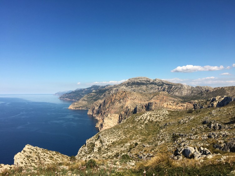
One section of the trail is actually really steep and there is a smaller climbing section. As we reach altitude the views get better and better. The whole western coastline of the island is made from steep cliffs.
We walk for about 4 hours and stay at the refuge Ses Fontanelles, where we booked two beds in a dorm. The place has no kitchen or even phone reception and it feels a bit like staying in a proper mountain hut.
Day 2: Ses Fontanelles – Estellencs / 12 km / 400 m ↑
On this stage I actually made a decision I regret now. I had been sent a not yet published hiking guidebook by my german publisher and took the description of the stage a bit too serious. It talked about a part that is not marked yet and where it is very easy to get lost on a scree slope. It even mentioned that one should be free of vertigo – which I’m clearly not. So I decided to skip the section in question by walking on the street. Later on I had to realize that the author of the guidebook in question set the bar really low. It would have clearly not been a section that was difficult for me…
Anyways, I walk for 7 km on the street, till I met Jens and the trail again. From there it’s another two hours to the village of Estellencs, where we finish this stage. Since there is no refuge or hostel we stay in a proper hotel with pool, spa and sauna.


Day 3: Estellencs – Esporles / 15 km / 640 m ↑
Today the trail leads us first to the village of Banyalbufar and then on to Esporles. I already notice how we are not getting done a lot of distance per day. The trail really has a lot of uphill and downhill sections (it’s basically steep all the time) and the kilometers pass quite slowly.
The first part of today’s hike is easy though. We pass through a private property, as it is usual in Mallorca, where almost the whole island is privately owned. Some land owners don’t really mind the trail and the hikers passing through their forest or over their fields. But some don’t want hikers on their grounds and the trail had been kept closed till the cases were taken to court. Now the whole trail is open – but signs to stay on the path, to remain silent and other regulations remind us that we are not welcome here. That’s an odd feeling, compared to hiking in Scandinavia, where one can walk and camp almost anywhere.
It was also our thought to wildcamp along the way, whenever possible. But I soon realize that it’s a bad idea for several reasons. The first one is the access to water: there are almost no streams or fountains. The water sources that exist usually have a sign that indicates poor water quality. Camping in the forest would mean carrying at least 5 liters of water per person, for cooking, washing the dishes, brushing your teeth and as drinking water for the next day of course.
Another reason to not camp, the most important one: if the land owners, who are opposing the trail, have proof of hikers camping on their lands, the path will probably be closed again. And honestly – if it was my property, I would also be doubtful how I would feel about people using my forest as a toilet, leaving their trash behind and making illegal camp fires (especially regarding the high risk of forest fires).
So we have no other choice but to find accomodation in the villages. There is usually at least one reasonably cheap option, sometimes in the dorm of a refuge, in a hostel or hotel. The prices range between 18 and 40 € per person.

Day 4: Esporles – Valldemossa / 11 km / 650 m ↑
After spending the night in a refuge with a cozy mountain shelter feeling to it, we start our ascend to Mola de sa Comuna mountain. The weather is not quite as nice as the days before and as we get up higher the landscape dissappears in the clouds. Soon we can’t see much anymore and ice cold gusts brush through the forest around us. Even like this the landscape is somewhat beautiful and the woods seem like in a fantasy movie.

There are several ruins and small cabins we pass. In the past, charcoal production took place in the forests of the island. As we reach the highest point for today, the wind is really strong and we don’t spend too much time up here.

Day 5: Deià – Valldemossa / 11 km / 820 m ↑
We decided to walk this stage backwards for two reasons: Accomodation in Valldemossa was too expensive, so that we had to take the bus to the next stage Deià; I rather walk very steep uphill than downhill, for the sake of my knees (yes, I’m old).
The way to Valldemossa leads up a 800 meter high crag. The trail winds up in zig-zags, until reaching a high plateau and the peak Es Caragoli. On the upper part of the rock face I really do feel weak in the knees and off balance – the cliff is almost vertical.

Up in the mountains the view dissappears in the fog again and we make our way downhill, towards Valldemossa.


Day 6: Deià – Sóller / 13 km / 350 m ↑
This stage is pretty easy and not very scenic. But it certainly is full with German tourists! I can’t really complain, since I’m a German tourist as well, but this island is really taken over by Germans. There isn’t even a need anymore to greet other hikers with an ¡Olá!, since everyone answers Hallo! anyways. On this stage we meet at least 80 people, which is way too much for my taste.

We stop for lunch by the lighthouse of Port de Sóller and some visitors look outraged at me as I fire up my gas stove. Yes, I’m sorry, were not all here for sightseeing from our rental car and for a three course meal in a fancy restaurant. It’s definitely one of the places where hikers and the general tourism in Mallorca clash and it just doesn’t fit. The island is small and densely populated. There is not a lot of space for visitors who want to spend little to no money.

Day 7: Sóller – Embalse de Cúber / 13 km / 980 m ↑
This stage is clearly one of the most scenic ones of the GR-221! In addition it is well marked (which is not the case on the first 5 stages) and the traditional stone path has been recently refurbished.
From the city of Sóller the trail winds up the Barranco de Biniaraix until topping out by the little farm L’Ofre. It’s almost a whole vertical kilometer but it feels surprisingly easy and only two hours after having a coffee in town (Jens had the coffee, I can’t handle coffeine) we are on top of the cliffs.
From here the path becomes less steep and reaches it’s highest point on the saddle Coll de L’Ofre. From this point we probably had the best view of the whole hike: one can see the Puig Major, the highest mountain of the island and the water reservoir Embalse de Cúber, framed by more mountains.

Behind the artifical lake lies the national road and from there we hitched a ride to the monastery of Lluc, where there is a camping ground. We finally want to camp and will spend two nights here. Tomorrow we will take the bus back to the lake and start the next stage from there again.
Day 8: Embalse de Cúber – Lluc / 13 km / 620 m ↑

If you had only time for a weekend hike in Mallorca, I would definitely recommend this stage and the day before. The whole stretch between Sóller and Lluc is unspoilt mountain landscape. No houses, no villages, no walking on asphalt.
From the Cúber reservoir the path continues along a water channel, until turning into another valley and gaining altitude. Soon the path climbs above the tree line and the Puig de Massanella, Mallorca’s second highest mountain, is now to the right.
After crossing the highest point of the whole trail the path goes downhill for a bit but soon leads up to another saddle again. From here you can look down to the Mediterranean and with good visibility both the Cap Formentor and the long beaches on the northern coast are visible.

Day 9: Lluc – Pollença / 19 km / 310 m ↑
After a rainy and surprisingly cold night of camping we start our last day. This stage goes almost only downhill, so it’s a fairly easy hike through the forest. Only the last 8 kilometers are not so attractive anymore, they run close to the national road and the mountains are already left behind.

Once arrived in Pollença, we celebrate completing the trail with a beer on the main square. I definitely enjoyed the trail and would recommend it to anyone looking for a warm weather hike in the colder months of the year.
Campgrounds and cheap food supplies are not as easy to find as in other areas (mainland Spain is way better) and you will need to buy bottled water most of the time.
The stages from Sant Elm to Deià are not all marked yet but the path is always well visible. It’s still quite important to bring a map and also the GPS-tracks. The most scenic part is between Sóller and Lluc. It would be possible to hike the whole ~ 120 km trail in five or six days but because of the constant uphill and downhill the stages tend to take quite a lot of time. We took it easy and walked no more than 4 – 5 hours a day.
General tips:
- Bring a warm jacket. After sunset or up the clouds it can be bitter cold, even in April.
- Always take at least 2 liters of water with you.
- Be super careful with open fire, the island is very dry.
- If you want to sleep in the refuges, you should book online, months ahead.
- Go light. There is no need for a heavy pack or big boots.
- Respect that wild camping is forbidden! If many hikers disrespect the rules, the trail will probably be closed again.
- The restaurants and smaller supermarkets have tourist prices. Don’t expect cheap food or drinks.


Hej Sara,
Först vill jag framföra, att jag tycker du skriver bra, intresseväckande och ger bra tips.
Jag funderar så smått på att gå GR 221, kanske redan nu i oktober. Av vissa äldre inlägg på webben framgår att vissa etapper, särskilt i början (dvs. sydliga delen) är dåligt markerade, dvs. det är lätt att gå fel, och man rekommenderar t.o.m. lokal guide. Men det verkar inte som om du/ni hade några svårigheter med vägfinnandet(?) Tycker du att det var lättorienterat hela vägen eller finns det svåra etapper som kan vara kinkiga för en ensamvandrare?
Hälsningar
Curt
LikeLike
Hej Kurt!
Tack så mycket!
Ja, den sydliga delen är ibland dåligt eller inte alls markerad. Jag skulle dock inte säga att det behövs en lokal guide, det fixar du. Vi använde GPS-spår och hade även en vandringskarta och guidebok med oss.
Det är mycket folk som vandrar där och har man en karta, så går man verkligen inte vilse! Leden är väl upptrampad och jag skulle inte tvivla att vandra där själv.
God tur, önskar jag 🙂
LikeLike
Enjoyed reading good information
LikeLike